Lately, Transoft Solutions has been receiving more and more requests for traffic analysis from video collected using drone cameras. While the usage of drone video for traffic monitoring is still relatively new, it is even more novel for video-based analytics purposes. Hence, it comes with its own set of advantages, limitations, and considerations. The purpose of this post is to present the benefits and challenges of using drone video for surrogate safety and traffic analysis. We hope this will help practitioners better determine when this collection method is most appropriate.
ADVANTAGES
Less cameras required:
In early 2020, we received a request to collect video at two large intersections in California. Given the typical traffic camera video quality, video processing from a camera installed on a pole is limited to about 100-130 feet (30-40 meters) in distance. Since these intersections measured about 200 x 200 feet (60 x 60 meters), they would have required a total of four cameras each in order to cover most of the areas of interest (Figure 1). However, one drone camera per intersection was all it took to cover all areas of interest, including both approaches.
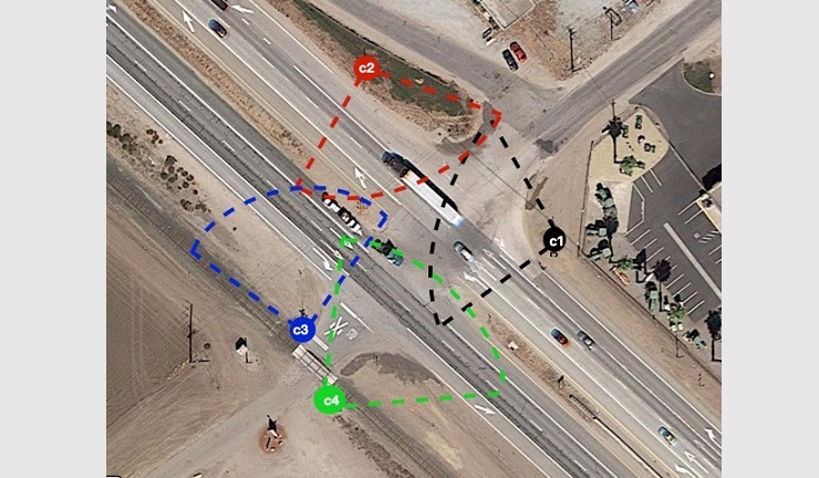
Figure 1. Initial proposed camera location setup
Infrastructure considerations are eliminated:
Not only did the two intersections mentioned above require four traditional cameras each, but we also ran into the problem of having nowhere to install the cameras. Typically for temporary installations, cameras are attached to public infrastructure, such as light poles at or near the road segment of interest (the typical setup is shown in Figure 2). This poses a challenge for several reasons. Sometimes, there are simply no poles to mount these cameras on to, which limits the possible locations to deploy at. Even when there is a pole, they might not be high enough (at least 15-20 feet/4.5-6 meters) or located close enough to the study zone to offer the best field of view. Lastly, video collectors require approval and permits from the road agency and/or the DOT in order to affix cameras to infrastructure, which may not always be easy or quick to obtain.
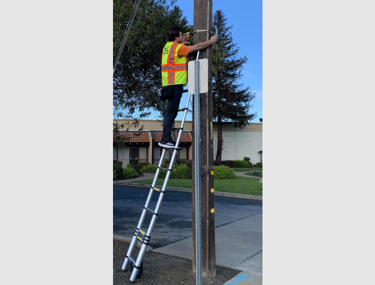
Figure 2: Typical camera set up
Wider coverage:
Often, due to poor video quality and/or infrastructure limitations, study areas can be limited to the intersection only. This means that little data beyond that of road user movements within and immediately around (crosswalks) the intersections are provided. Since drones have a much wider field of view, it means our analytics can provide much more contextual data. For example, metrics on how vehicles are behaving before entering the intersection, or upon leaving the crosswalk. Having a wider coverage area simply means more useful traffic data! Figure 3 displays the final setup with drone video in California.
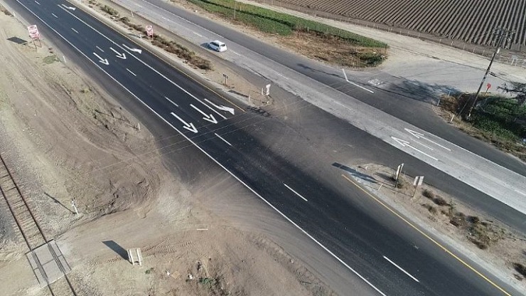
Figure 3. View from final drone camera set up in California
The use of drone video allows us to get around the constraints that sometimes come with fixed cameras. Using drone video for this project in California allowed for the whole intersection to be within view of just a single drone camera. This significantly simplified the project scope and camera setup and lowered the cost and time of video collection and processing.
Coverage at any road segment or shared space:
Since collecting with drone video eliminates the need for nearby poles, it allows for the possibility of collecting video at locations like highways, bridges, or midblock locations with no nearby poles. For example, in Figure 4 below, video was collected at an intersection near a plant where poles were not widely present. The drone camera also captured a much larger zone than would have been captured with a camera attached to a pole.
Figure 4. Video collected using a drone camera in Texas
Crisper video quality:
Counting cars using traffic cameras has been around for well over a decade. Since counting cars doesn’t require high resolution, these cameras are not always well suited for detecting and tracking varying types of road users from afar. However, drone video quality is extremely high, not only making the detection and tracking of all road users easier, but also nicer to look at, and easier to review. Figure 5 displays the same road segment covered by a typical traffic camera vs. a drone.
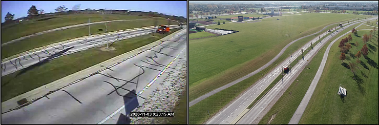
Figure 5. Road coverage using a standard camera (left) vs. drone video (right) in Chicago
LIMITATIONS
Availability and affordability:
Collecting drone video is still new, and not all video collectors across all geographical areas offer drones. In addition, in cases where the usage of a drone is substituting the use of a single fixed camera, the costs are generally more expensive. However, assuming the availability is there, drone collection is almost always more financially beneficial in situations where a drone is replacing a two- to four- fixed camera setup.
Short battery life:
Another challenge is the short battery life of drones. Drone batteries generally do not last more than15 to 20 minutes. In theory, this makes it impossible to get continuous video from a single drone for the duration required for a typical automated road safety study (24 to 60 hours). However, this challenge is easily overcome by using two drones during the same collection period – one drone replaces the other while it charges. These two drones are constantly interchanged (using preset coordinates) throughout the video collection period, providing seemingly continuous video footage.
Weather can put a damper on video collection:
Since drones are air-bound, they are highly affected by weather conditions. Strong winds may cause the drone to either drift or completely rotate its field of view. To avoid this, weather conditions should be considered when selecting the date of video collection.
Limited video footage hours:
Temporary fixed cameras can be installed and generally left unattended, (apart from a potential battery or memory card change), drone video, however, requires the constant presence of an operator. This increases the amount of effort required to collect video footage linearly. On average, it is generally possible to collect between six to nine hours of video footage per day. While this may be a concern when more hours are required to obtain statistically significant data, drone footage is usually used to cover a large stretch of land, meaning that volumes are high and that less video footage is required.
FINAL CONSIDERATIONS
Now that all of the advantages and disadvantages of using drone video have been explained, there are some additional considerations to keep in mind when using drone video for automated traffic flow and road safety studies:
Detecting vulnerable road users:
With properly positioned video, our current video analytics can detect up to 15 road user types with a high degree of accuracy – this includes pedestrians, cyclists, e-scooters, and motorcycles, in addition to all motorized vehicle classes. Some of these road users are notably smaller than others and thus may be harder to detect (even using the human eye) if a larger coverage area is required. This should be taken into consideration when selecting the location of interest, selecting the coverage area, and positioning the drone. Below are examples of different drone setups and different clarities of vulnerable road users. The first two drones are placed at an appropriate height to cover pedestrians and cyclists, while the third setup is primarily focused on motorized vehicles. All setups were appropriate for the intended study purposes.
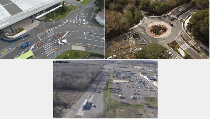
Figure 6. Different drone setups focusing on different road user types
Nighttime footage:
The usage of drone footage is not ideal at night. This is due to multiple factors, including safety and permits. Additionally, lighting conditions play an important factor. Keeping in mind that drone footage is a great substitute for locations without poles (namely light poles), this means that some of these locations are not illuminated at night, and thus the footage could be too dark to produce reliable results. Video collection hours should therefore be selected such that natural light is available.
Drone permits and regulations:
Again, with the usage of drone video being relatively new, rules and regulations are still evolving. Before the location of interest is selected, ensure that all the regulations and rules are met for that location. Generally, this should not pose a problem and any reputable video collector should be able to provide you with the necessary permits/permission.
Overall, drone collection is becoming increasingly common, and it certainly has its advantages. For certain projects, drone collection should be considered as a potential method of video data collection. On our side, we are keeping up with the evolution of the industry. Our road user detection and tracking capabilities are strong under both video collection scenarios, and we continue to improve our detection algorithms so that many of the limitations mentioned above will quickly become problems of the past.